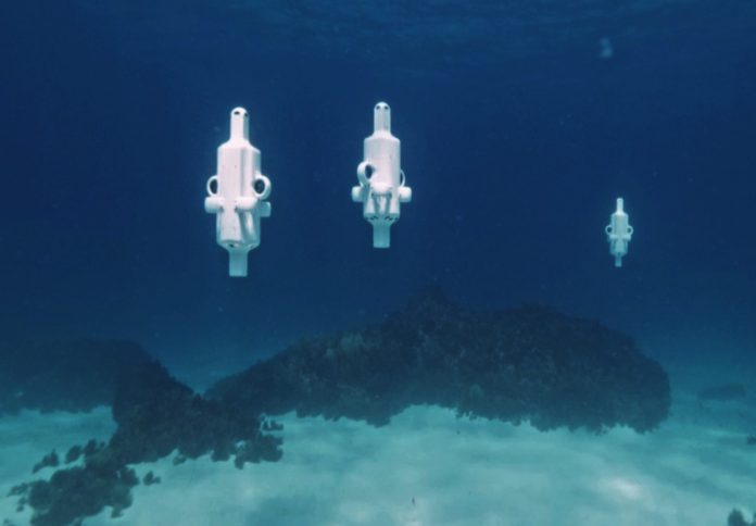
An autonomous underwater robot has revealed significant coral bleaching at Hall Bank, a high-latitude reef off the coast of Fremantle, in a survey conducted by navigation technology company Advanced Navigation and marine consultancy O2 Marine.
The reef, located at 32°S and considered one of the world’s southernmost coral systems, was mapped using Hydrus, a micro-hovering autonomous underwater vehicle (AUV) developed by Advanced Navigation.
The survey recorded high-resolution geo-referenced imagery and 4K video of the reef, which showed extensive bleaching and coral fragmentation.
“Unlike traditional underwater vehicles, Hydrus’s compact design, fleet deployability, and ability to gather professional-grade data allow us to monitor reefs at a scale and frequency previously unattainable,” said Claudio Del Deo, Co-Managing Director at O2 Marine.
“This level of detail is essential for informing conservation strategies and building the baseline needed for long-term reef recovery.”
The data was used to produce a 3D digital twin of the Hall Bank seabed, capturing fine-scale changes often missed by conventional survey methods.
The reef, regarded as a natural underwater laboratory due to its ability to support diverse coral species in colder, turbid waters, is now showing signs of stress.
The findings follow widespread coral bleaching in March 2025 at both of Australia’s world heritage-listed reef systems – Ningaloo and the Great Barrier Reef – triggered by sea surface temperatures up to 4°C above average.
“To truly understand the extent of coral bleaching, we need high-resolution, spatially accurate data that captures both the scale and the fine detail of change beneath the surface,” Del Deo said.
Three Hydrus units were deployed simultaneously during the mission, operating in coordinated transects to ensure full spatial coverage of the site. This method enabled detailed mapping of reef structure and condition across different sections.
Alec McGregor, Senior AI Engineer at Advanced Navigation, said Hydrus is helping overcome the challenges of traditional ocean data collection.
“Collecting high-quality ocean data has traditionally been slow, costly, and resource-intensive, where sending divers or ROVs below 50 metres can run into tens or hundreds of thousands of dollars,” McGregor said.
“Hydrus changes the equation. At just 7kg, it can be deployed by a single person, without support vessels or complex logistics.”
The Hall Bank mission aligns with broader ocean-mapping goals, including the global Seabed 2030 initiative and the United Nations Decade of Ocean Science. According to Advanced Navigation, only 26.1 per cent of the ocean floor has been mapped to date.
The company has previously used Hydrus for similar missions, including a 2024 survey that discovered a 64-metre shipwreck in the Indian Ocean.
Data from that mission was used to create a high-resolution digital replica now housed in the Western Australian Museum’s collection and displayed at Curtin University’s HIVE facility.
“This mission is a powerful example of what’s possible when cutting-edge robotics meets urgent environmental challenges,” McGregor said.
“Hydrus puts critical data into the hands of scientists and marine operators faster, more safely, and more affordably—enabling smarter, more timely decisions for conservation and climate adaptation.”


